|
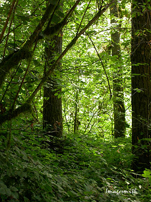 Traveling
the McKenzie River Valley is always a visual treat. Leaving the
Springfield/Eugene area, you pass through sleepy little communities like
Cedar Flat and Walterville with their farmed fields, open spaces, irrigation
canals and the occasional hazelnut orchard. Traveling
the McKenzie River Valley is always a visual treat. Leaving the
Springfield/Eugene area, you pass through sleepy little communities like
Cedar Flat and Walterville with their farmed fields, open spaces, irrigation
canals and the occasional hazelnut orchard.
Then the road begins to climb slightly and
the forest that seemed distant creeps closer, a wonderland of Douglas fir and other conifers
intermixed with deciduous species, with ferns and other groundcover below.
Each season unfolds a look of its own: spring with its fragile unfurling
foliage; summer's vibrant umbrella of greenery; fall slipping into
warm tones as leaves fall and the trees prepare for the chill dormancy of
winter.
Though it's a major artery across the
Cascades, Highway 126 is only one
lane each way. Often you have the road to yourself, a
personal path through the green wonderland that is the forest. |
|
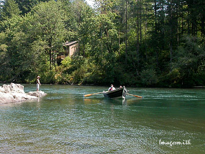
A drift boat on the McKenzie River near Vida. Note the
distinctive bowed hull shape designed to maintain stability amid the
low rapids of the river. The McKenzie is a magnet for river lovers:
kayakers, fishermen, rafters. The highway follows the river, and along
the way cabins are tucked away among the trees along the river's banks,
perfect spots for lazy summer getaways. |
|
Along the highway, numerous turnouts lead to boat ramps or
picnic areas. Oregon does a great job of providing easily
accessible facilities without a wholesale paving-over of the landscape.
At Ben and Kay Dorris State Park, pictured here, scattered picnic tables are
tucked away just off neat foot trails throughout the landscape, affording
the chance to appreciate the surroundings. |
|
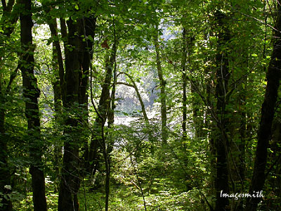
 Gradually the road grows steeper, climbing into the
Cascades. Open fields become more scarce until they finally disappear,
and forest and river, and the occasional lake, are all you see. Beside
the road in the picture above, two waterfalls stream down a sharp cliff
face. The first time I saw this area was in the middle of winter.
We'd traveled from Bend over the snow- and ice-packed road, the forests
white, silent and nearly colorless around us. In this spot the
waterfall had frozen into spectacular, long icicles. Gradually the road grows steeper, climbing into the
Cascades. Open fields become more scarce until they finally disappear,
and forest and river, and the occasional lake, are all you see. Beside
the road in the picture above, two waterfalls stream down a sharp cliff
face. The first time I saw this area was in the middle of winter.
We'd traveled from Bend over the snow- and ice-packed road, the forests
white, silent and nearly colorless around us. In this spot the
waterfall had frozen into spectacular, long icicles. |
|

Finally we reach
our destination: Clear Lake, the McKenzie River's source.
Formed thousands of years ago after the eruption of a nearby
volcano, the lake is said to be 150-200 feet deep. The water
reaching it seeps through miles of volcanic rock, and it is
suggested that this is one of the reasons for the lake's astonishing clarity,
for in many places you can see all the way to the bottom, to where
ancient trees still lie intact, preserved in its frigid waters.
|
